Peirce Quincuncial
| Peirce Quincuncial | |
|---|---|
| Creator | Charles Sanders Peirce (1879) |
| Group | Miscellaneous |
| Property | Conformal |
| Other Names | — |
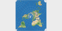
| Remarks | The equator (red line in the image) is a square whose corners are the only four points on the map which fail to be conformal. In the image, the map is centered to 20° West. |
Jump to different depiction of this projection:
Specified in [square brackets]: Actual size of the projection
(minus the black or white background).
When marked with [≈], sizes with and without
background are approx. the same.