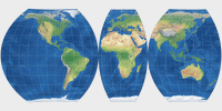
Wagner VII (interrupted)
| Wagner VII (interrupted) | |
|---|---|
| Creator | Karlheinz Wagner (1941) |
| Group | Lenticular |
| Property | Equal-area |
| Other Names | — |
| Remarks | This variant uses the segmented interruption scheme. Quoting the Geocart Manual: This scheme is for presenting the continents with low distortion and symmetry about the equator. It splits the Eurasian landmass approximately at the conventional division of Europe and Asia. Additionally, the projection was slightly stretched horizontally while maintaining equivalence. |
Jump to different depiction of this projection:
Specified in [square brackets]: Actual size of the projection
(minus the black or white background).
When marked with [≈], sizes with and without
background are approx. the same.