License information for Azimuthal equal-area (polar)
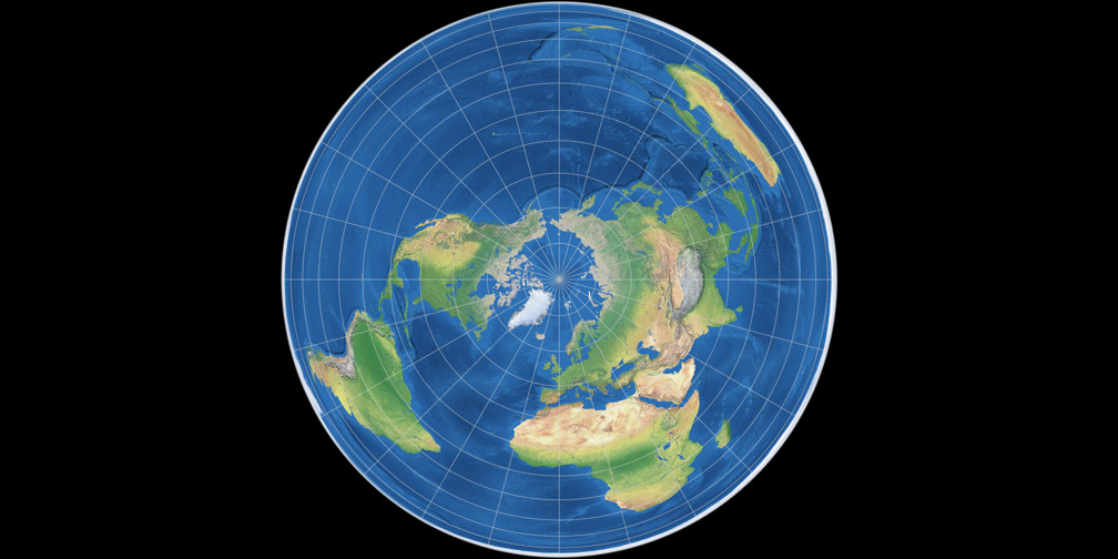
| Description | Azimuthal equal-area (polar) Map Projection Image, physical map. 15° graticule. | |||
|---|---|---|---|---|
| Resolution | 1008 × 504 [503 × 504] | |||
| File Size | 123.57 KB | |||
| MIME type | image/jpeg | |||
| License |
 Azimuthal equal-area (polar) Map Projection Image by Tobias Jung is licensed under a Creative Commons Attribution-ShareAlike 4.0 International License. Image is based on Natural Earth II by Tom Patterson with darkened colors. |
|||
Use this file in own projects
Downloading and using the image is allowed within the scope of the above-mentioned licence.
Please use the build-in functions of your web browser to download the image above.
To share the image, use the
single view.
The nifty little download function that used to be here (to download the image with a single click and to prevent file name conflicts with other images of the same projection) was removed due to heavy traffic caused by bulk downloads. Sorry!
| Download |
Download The file will be saved to you harddisk using the file name azimutal-equal-area-gpolar-projection-physical-map-1008x504.jpg In case that doesn’t work, open the image in your web browser and save it manually. |
| Share | To share the image, use the single view. |
Use this file on the web
Please respect the terms as stated in the CC BY-SA 4.0 License.
Whenever possible, please download the image to install it on your own website rather than using the
File URL given above to embed it.
Further Images of Azimuthal equal-area (polar)
Note: Occasionally, the variants of »other« sizes might be almost or even exactly the same size.
Specified in [square brackets]: Actual size of the projection
(minus the black or white background).
When marked with [≈], sizes with and without
background are approx. the same.
Other Resolutions
- Azimuthal equal-area (polar), physical map (1008 × 1008) [≈]
Other depictions
- Azimuthal equal-area (polar), thumbnail (200 × 100)
- Azimuthal equal-area (polar), thumbnail (flat ocean) (200 × 100)
- Azimuthal equal-area (polar), physical map (flat ocean) (1008 × 504) [503 × 504]
- Azimuthal equal-area (polar), physical map (flat ocean) (1008 × 1008) [≈]
- Azimuthal equal-area (polar), political map (1008 × 504) [503 × 504]
- Azimuthal equal-area (polar), political map (1008 × 1008) [≈]
- Azimuthal equal-area (polar), Tissot indicatrix, 15° (1008 × 504) [503 × 504]
- Azimuthal equal-area (polar), Tissot indicatrix, 15° (1008 × 1008) [≈]
- Azimuthal equal-area (polar), Tissot indicatrix, 30° (1008 × 504) [503 × 504]
- Azimuthal equal-area (polar), Tissot indicatrix, 30° (1008 × 1008) [≈]
- Azimuthal equal-area (polar), green silhouette map (1008 × 504) [503 × 504]
- Azimuthal equal-area (polar), green silhouette map (1008 × 1008) [≈]
- Azimuthal equal-area (polar), red silhouette map (1008 × 504) [503 × 504]
- Azimuthal equal-area (polar), red silhouette map (1008 × 1008) [≈]